




Munro Bagging

Mô tả của Munro Bagging
Munro Bagging is an application that allows you to browse through all of the significant hills in Britain, including the Munros, the Murdos, the Grahams, Marilyns and Corbetts.
As well as providing information on each hill (useful for walk planning), you can record notes from when you climbed it.
Features:
- Search for hills by name
- List hills by name, height or region
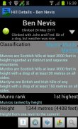
- See information on hills' classification, height, prominence, location, summit features and useful Ordnance Survey maps
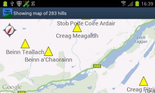
- View hill location on a map, either individually or all together
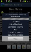
- Get bearing and distance from the phone's current location to the hill summit
- Audio pronunciations of hill names, via the optional Munro Bagging Sounds extension application
Features to come:
- Import/export climb notes to file, to allow migration between phones
- Integration with photo albums
- Social media integration ("share my climb")
Uses data from the Database of British and Irish Hills (<a href="https://www.google.com/url?q=https://www.google.com/url?q%3Dhttp://www.hills-database.co.uk/%26sa%3DD%26usg%3DAFQjCNF5WWSxNsuEG8kmL2Q-f1gsadAJEA&sa=D&usg=AFQjCNHS1qF4GFX0vmksxt-RDOdc7g7A6Q" target="_blank">http://www.hills-database.co.uk/</a>), licensed under Creative Commons 3.0.
Audio clips supplied by and used with kind permission of Comunn na Gàidhlig (CnaG) (<a href="https://www.google.com/url?q=https://www.google.com/url?q%3Dhttp://www.cnag.org.uk/%26sa%3DD%26usg%3DAFQjCNGXmnIk-wTCvGOwlklmmfvgxI20Jw&sa=D&usg=AFQjCNFOeR-ZRMwLFdmOOdZnc0j-Cb6-iA" target="_blank">http://www.cnag.org.uk/</a>)
</div> <div jsname="WJz9Hc" style="display:none">Munro đóng bao là một ứng dụng cho phép bạn duyệt qua tất cả các ngọn đồi lớn ở Anh, bao gồm cả Munros, các Murdos, các Grahams, Marilyns và Corbetts.
Cũng như cung cấp thông tin trên mỗi đồi (hữu dụng cho việc lập kế hoạch đi bộ), bạn có thể ghi lại các ghi chú từ khi bạn leo lên nó.
Các tính năng:
- Tìm kiếm theo tên đồi
- Danh sách đồi theo tên, chiều cao hoặc khu vực
- Xem thông tin về phân loại, chiều cao, nổi bật, vị trí, tính năng hội nghị thượng đỉnh đồi và bản đồ Cục bản hữu ích
- Xem vị trí đồi trên một bản đồ riêng biệt hoặc tất cả cùng nhau
- Nhận mang và khoảng cách từ vị trí hiện tại của điện thoại để hội nghị thượng đỉnh đồi
- Âm thanh phát âm của tên đồi, thông qua tùy chọn Munro đóng bao Âm thanh ứng dụng mở rộng
Tính năng đến:
- Nhập khẩu / xuất khẩu lên ghi vào tập tin, cho phép chuyển đổi giữa các điện thoại
- Tích hợp với các album ảnh
- Tích hợp phương tiện truyền thông xã hội ("chia sẻ lên của tôi")
Sử dụng dữ liệu từ cơ sở dữ liệu của Anh và Ailen Hills (<a href="https://www.google.com/url?q=http://www.hills-database.co.uk/&sa=D&usg=AFQjCNF5WWSxNsuEG8kmL2Q-f1gsadAJEA" target="_blank">http://www.hills-database.co.uk/</a>), cấp phép theo Creative Commons 3.0.
Các đoạn âm thanh được cung cấp bởi và được sử dụng với sự cho phép loại Comunn na Gàidhlig (CnaG) (<a href="https://www.google.com/url?q=http://www.cnag.org.uk/&sa=D&usg=AFQjCNGXmnIk-wTCvGOwlklmmfvgxI20Jw" target="_blank">http://www.cnag.org.uk/</a>)</div> <div class="show-more-end">


